the weather authority
Above-average highs, scattered inland storms Sunday afternoon
The Weather Authority says after a rainy Saturday evening, we are kicking off Sunday drier with partly cloudy skies overhead.
The Weather Authority continues to monitor Hurricane Helene, a Category 1 storm that is now forecast to increase to a Category 4 storm before hitting the Florida Panhandle.
According to the National Hurricane Center’s 2 a.m. Thursday advisory, Helene is moving toward the north at 12 mph.
The latest advisory shows it strengthening into a Category 4 storm at around 2 p.m. on Thursday.
As of the latest advisory, maximum sustained winds were near 85 mph with higher gusts.
It’s expected to continue its northward motion through Friday.
After landfall, Helene is expected to slow down and turn toward the northwest over the southeastern United States on Friday and Saturday.
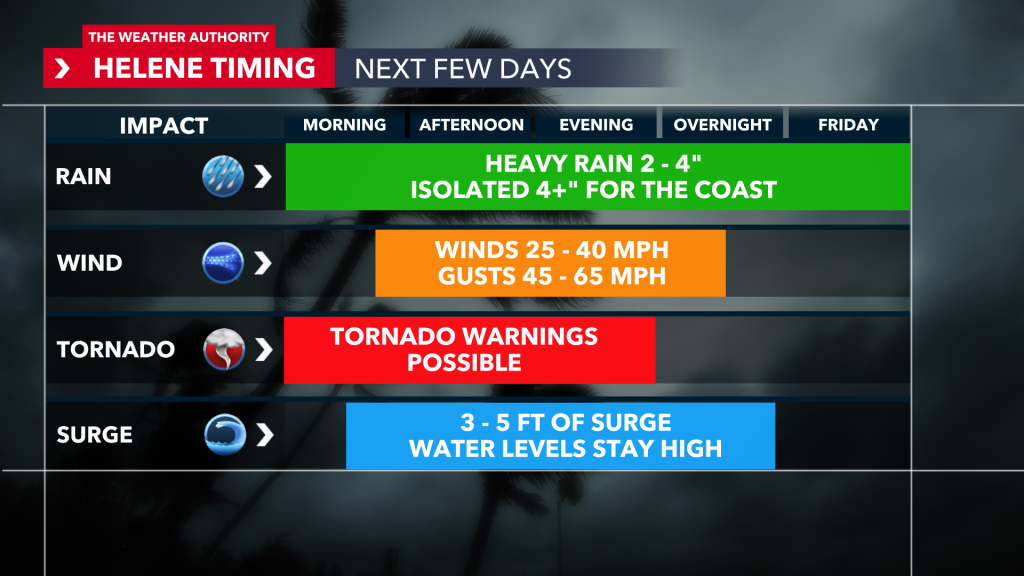
The Weather Authority Meteorologist Zach Maloch said, “In Southwest Florida, the storm’s closest point will be Thursday afternoon, aligning with the strongest point before landfall.”
The latest forecast has remained relatively consistent.
The storm’s future track sees the center of Helene move across the eastern Gulf of Mexico on Thursday and reach the Big Bend coast of Florida later Thursday, where it will make landfall.
Helene is expected to be a major hurricane.
Weakening is expected after landfall, but Helene’s fast-forward speed will allow strong, damaging winds, especially in gusts, to penetrate well inland across the southeastern United States.
While the storm’s center won’t directly impact Southwest Florida, we’ll see impactful and stormy weather through Friday.
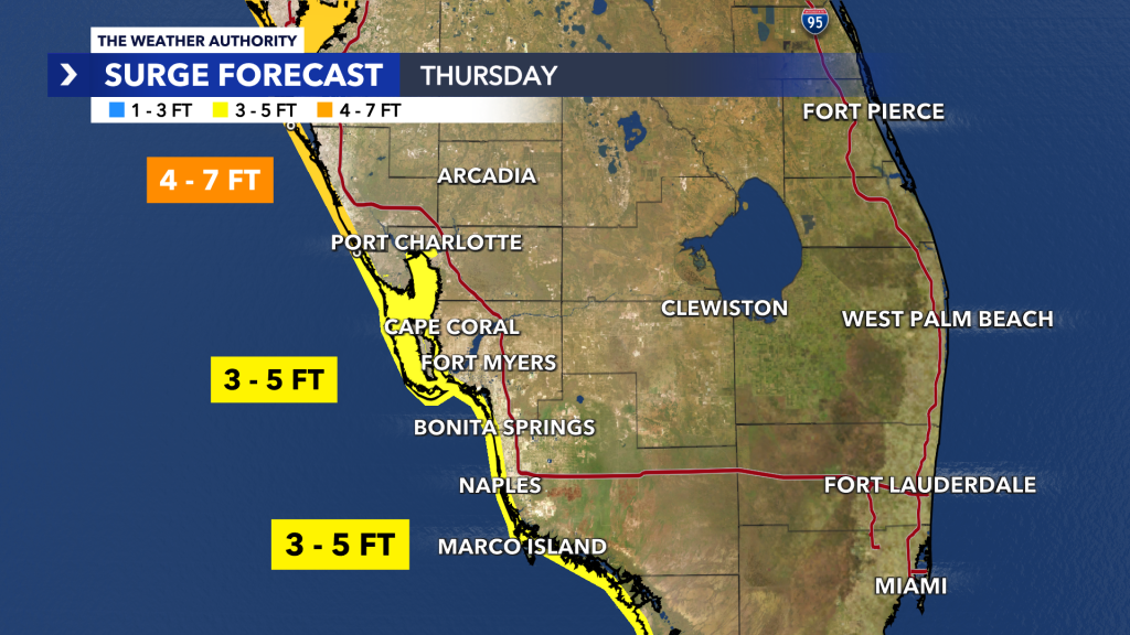
A Storm Surge Warning is in effect for
A Hurricane Warning is in effect for
A Hurricane Watch is in effect for
A Tropical Storm Warning is in effect for
Download the WINK Weather app, stream the latest forecast or WINK Doppler 3x anywhere you go.
If you see any dramatic weather images that you want featured in a story online or on air, send them tips@winknews.com.