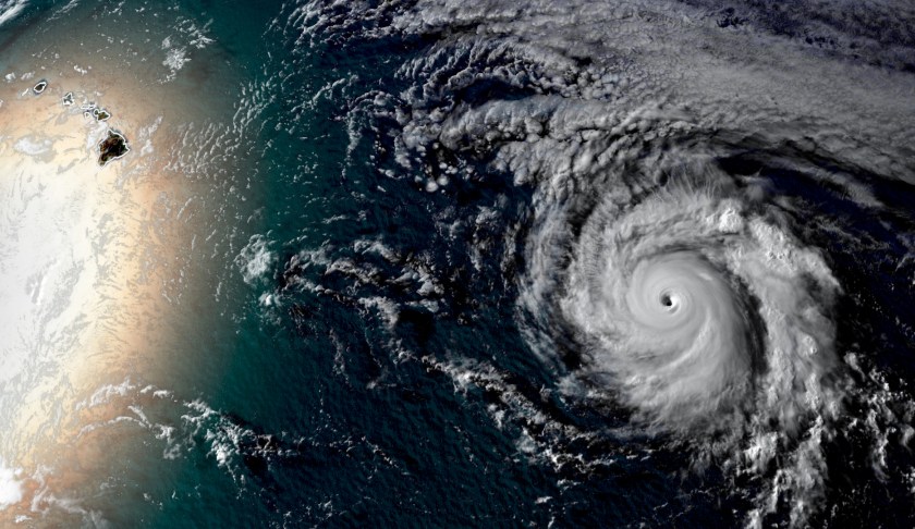
 Hurricane Douglas, the strongest storm on the planet, moves toward Hawaii. (CNN Weather)
Major Hurricane Douglas it currently approaching Hawaii. The storm is a category 3 hurricane, packing dangerous winds of 120 mph that extend 25 miles from the center of the storm, according to the Central Pacific Hurricane Center. A major hurricane is any storm ranked category 3 — winds 111 to 129 mph — or stronger.
“The Hawaiian Islands should monitor the progress of Douglas,” the National Hurricane Center (NHC) says. “There is an increasing chance that strong winds, dangerous surf, and heavy rainfall could affect portions of the state beginning Saturday night or Sunday.”
Tropical storm-force winds are forecast to arrive on the Big Island as early as Saturday evening local time.
The storm is 895 miles east-southeast of Hilo, Hawaii and is moving west-northwest directly toward the island chain. The good news is this major hurricane is forecast to begin weakening today as it interacts will cooler water and drier air.
Douglas is expected to be a category 1 — winds 74 to 95 mph — hurricane as it approaches the islands this weekend.
It is likely to weaken even more as it approaches Hawaii and will quickly transition to a tropical storm as it moves over the state.
Some forecast models take the storm directly over the Big Island, some thread the needle between the islands and others take the storm just north of the island chain.
It is important to not focus on the center of the forecast track but know that the storm could hit anywhere within the forecast cone issued by the NHC.
“It is fairly common for hurricanes to track towards Hawaii, but they usually dissipate or at least weaken considerably before impacting the islands,” Phil Klotzbach, a research scientist at Colorado State University, said. “For example, both Lane and Olivia impacted Hawaii in 2018. Also, in 2016, both Lester and Madeline threatened Hawaii.”
Although a hurricane’s effects on Hawaii can be severe, it is rare for major hurricanes to reach the island chain’s shores. For one, the Hawaiian Islands are a small plot of land amongst the world’s largest ocean basin, making the statistical probability of a direct landfall very low.
Hawaii covers 6,423 square miles of land divided up among six main islands, making the chance of a direct landfall even less likely. Florida, by comparison, is a significantly easier target for hurricanes to strike as it covers more than 50,000 square miles.
Slow start to the East Pacific hurricane season
In a season that has seen early storm formation in the Atlantic, the eastern Pacific has been slower for storm development than in previous years.
“During the period of reliable records, this is the 4th latest date in which the first hurricane of the season has formed,” according to the NHC.
A slow Pacific hurricane season, especially when paired with an active Atlantic hurricane season, is a sign of a La Niña event, which forecasters have predicted could occur this year.
Under La Niña, global convection wind currents yield sinking air over the eastern Pacific, and rising air over the western Atlantic. Sinking air patterns increase wind shear, a sudden shift in wind direction, speed or both, which can rip apart hurricanes before they have a chance to grow. Rising air creates a favorable environment for tropical storm development, which is why all eyes are on the Atlantic this season.
The-CNN-Wire
™ & © 2020 Cable News Network, Inc., a WarnerMedia Company. All rights reserved.


