
LABELLE
Small plane crash reported in LaBelle
A small plane crash was reported in LaBelle.
SHOWING RESULTS FOR:
Filter results by:
Please try another search or check out the latest stories below.
A small plane crash was reported in LaBelle.

United States Coast Guard air and surface crews are searching for a man who reportedly failed to resurface while freediving from a vessel 69 miles west of Naples.

As Charlotte County officials struggle to restore beaches and structures damaged from recent hurricanes, a new tourism trend has emerged. While visitors continue to flock to Charlotte County, more have chosen to visit and stay in Punta Gorda due to hurricane damage in Englewood and Manasota Key, according to the Punta Gorda/Englewood Beach Visitor & Convention Bureau.

Naples residents have plenty to celebrate as the Seafood & Music Festival is set to return.

A push to make boating safer in Florida is gaining momentum as a bill known as “Lucy’s Law” advances through the legislative process.

The interior and part of the exterior of the former Barnes & Noble building at Waterside Shops are being demolished to enable the buildout of that two-story space for Williams-Sonoma and Pottery Barn home furnishing stores, which are expected to relocate there later this year or early next year.

The Cape Coral Police Department has arrested a man accused of driving under the influence after he crashed his vehicle with a child inside.

As construction may dampen your commute, WINK News traffic anchor Rachel Cox Rosen knows the best way to traverse the roadways in this web-exclusive feature.
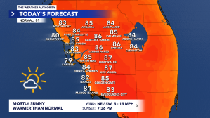
The Weather Authority is tracking a drier Friday with afternoon temperatures reaching highs similar to mid-February.

Authorities have arrested five individuals and are searching for a sixth suspect in connection with a major car theft ring in Florida.

A Naples construction supervisor faces serious allegations after being accused of using his position to sexually assault employees.

According to the Hendry County Sheriff’s Office, there is a police presence in the area of Sioux Avenue and Cheyenne Avenue.

The Cape Coral Police Department is urging residents to lock their car doors to prevent vehicle burglaries.

Charlotte County Sheriff Bill Prummell is pushing for a new bill that aims to prevent cases like that of Tristin Murphy from happening again.

The Tampa Bay Rays aren’t moving forward with a new stadium and will instead repair Tropicana Field for 2026 as fans wonder about the future.
A small plane crash was reported in LaBelle.
United States Coast Guard air and surface crews are searching for a man who reportedly failed to resurface while freediving from a vessel 69 miles west of Naples.
As Charlotte County officials struggle to restore beaches and structures damaged from recent hurricanes, a new tourism trend has emerged. While visitors continue to flock to Charlotte County, more have chosen to visit and stay in Punta Gorda due to hurricane damage in Englewood and Manasota Key, according to the Punta Gorda/Englewood Beach Visitor & Convention Bureau.
Naples residents have plenty to celebrate as the Seafood & Music Festival is set to return.
A push to make boating safer in Florida is gaining momentum as a bill known as “Lucy’s Law” advances through the legislative process.
The interior and part of the exterior of the former Barnes & Noble building at Waterside Shops are being demolished to enable the buildout of that two-story space for Williams-Sonoma and Pottery Barn home furnishing stores, which are expected to relocate there later this year or early next year.
The Cape Coral Police Department has arrested a man accused of driving under the influence after he crashed his vehicle with a child inside.
As construction may dampen your commute, WINK News traffic anchor Rachel Cox Rosen knows the best way to traverse the roadways in this web-exclusive feature.
The Weather Authority is tracking a drier Friday with afternoon temperatures reaching highs similar to mid-February.
Authorities have arrested five individuals and are searching for a sixth suspect in connection with a major car theft ring in Florida.
A Naples construction supervisor faces serious allegations after being accused of using his position to sexually assault employees.
According to the Hendry County Sheriff’s Office, there is a police presence in the area of Sioux Avenue and Cheyenne Avenue.
The Cape Coral Police Department is urging residents to lock their car doors to prevent vehicle burglaries.
Charlotte County Sheriff Bill Prummell is pushing for a new bill that aims to prevent cases like that of Tristin Murphy from happening again.
The Tampa Bay Rays aren’t moving forward with a new stadium and will instead repair Tropicana Field for 2026 as fans wonder about the future.

The Weather Authority is tracking a drier Friday, with afternoon temperatures reaching highs similar to mid-February.
The Weather Authority Meteorologist Zach Maloch said, “Thanks to southeast wind, afternoon highs will be warmer than the last couple of days.”

After a milder and more humid start this Friday morning, we’ll see a warmer afternoon ahead.
Temperatures will top out in the mid-80s, making this Friday one of the warmest days we have seen since mid-February.
We’ll stay nice and dry with a mixture of sun and clouds throughout the day.

Breezy conditions will be in the forecast for your weekend plans as a strong storm system moves across the northern Gulf Coast.
We’ll also see warm and humid conditions, with temperatures climbing into the mid- to upper 80s.
Some communities can flirt with 90°, making Saturday one of the warmest days we have seen so far this year.
Warm and breezy conditions continue for Sunday, with sustained winds from 15 to 25 mph and gusts between 30 and 40 mph.
A few showers are possible, but most of Sunday will stay dry.
Highs top out in the mid- to upper 80s.